Integrated
 Mineral resource
 Sustainable
 Implats Annual

“The agreement which involves the transfer of the Implats-owned Tamboti mineral rights to Two Rivers has been concluded. As a result the Implats shareholding in Two Rivers has increased to 49% from the previous 45% interest

Mineral rights Two Rivers

Two Rivers locality map

Two Rivers is located on the eastern limb of the Bushveld Complex, some 35km south-west of Burgersfort. The location is shown in the adjacent map.
During 2001, Assmang elected to dispose of its platinum interests at the Dwarsrivier Chrome Mine. Two Rivers, the incorporated joint venture between Avmin and Implats, secured the platinum rights in December of that year. Subsequent corporate activity involving Avmin, African Rainbow Minerals (ARM) and Harmony resulted in the transfer of Avmin’s share in Two Rivers to a new, empowered platinum entity, ARM Platinum, a division of ARM. The joint venture partners began development of the Two Rivers project in June 2005. The concentrator plant was commissioned early in 2007 and in 2008 the mine successfully made the transition from project to operation.
Two Rivers was granted a new-order mining right in 2013 over 2 140ha on a portion of the farm Dwarsrivier. In 2015 portions 4, 5 and 6 of the adjoining farm, Kalkfontein, as well as portions of the farm Tweefontein held by Impala was incorporated into the Two Rivers mining right. An agreement was also reached for the remaining Implats-owned mineral rights on portions of the farms Kalkfontein and Buffelshoek in exchange for a royalty payment. The operation is managed by ARM and Implats has a 49% stake in the joint venture. Both the Merensky and UG2 Reefs are present but only the UG2 is currently exploited. However, no Merensky Reef is present on Tweefontein and the UG2 Reef only occurs on a small portion of this farm. The UG2 Reef outcrops in the Klein Dwarsrivier valley over a north-south strike of 7.5km and dips to the west at 7° to 10°. The vertical separation between the Merensky and UG2 Reefs is around 140m to 160m. Due to the extreme topography, the Merensky Reef outcrops further up the mountain slope. The topography also means that the UG2 occurs at 935m below surface on the western boundary. The geological succession is broadly similar to other areas of the eastern limb of the Bushveld Complex. An exception is the presence of the Steelpoortpark granite in the south-western part of the project which is unique to this area. Three distinct reef types have been defined for the UG2 Reef, namely the “normal” reef with a thick main chromitite layer; a “split” reef characterised by an internal pyroxenite/norite lens within the main chromitite layer; and a “multiple split” reef with numerous pyroxenite/norite lenses occurring within the main chromitite layer. The multiple split reef predominates in the southern portion of the mining area.
The Merensky Reef is a pyroxenite layer with a chromitite stringer close to the hangingwall contact and also at the basal contact. Mineralisation is primarily associated with the upper and lower chromitite stringers. The grade profiles at Two Rivers are generally similar to that at the adjoining Tamboti Project. The graphical illustration of the profiles is shown below. The geological structure of the area is dominated by the regional north-northeast to south-southwest trending Kalkfontein fault which has an apparent vertical displacement of 1 200m down throw to the west. A series of sub-parallel faults occur to the south-east adjacent to the Kalkfontein fault which affect both the MR and UG2 Reefs. These faults exhibit variable apparent vertical displacements of between 20m and 300m which increase progressively to the south-west. The UG2 orebody is accessed via two decline shaft systems situated 3km apart, namely the Main Decline and the North Decline. Reef production is through a fully mechanised bord and pillar stoping method. A mining section consists of eight 12m bords, with pillar sizes increasing with depth below surface. In the shallow areas up to 100m below surface, the pillars are 6m x 6m in size. The rooms are mined mainly on strike. A 3D geological model with layer grades and widths per stratigraphic unit is utilised. The mine scheduling of the two declines is done in Mine 2-4D™. The schedule is evaluated against the grade and thickness block model. The three distinct reef types impact significantly on the mine plan. |

Dilution calculations are based on the specific reef type and pay limits are applied to the final mining cut. Hangingwall and footwall overbreak, percentage off-reef, ore remaining (mining losses), geological losses (potholes, faults, dykes and replacement pegmatoid) and a shaft call factor are applied to the planned areas to generate the tonnage and grade profiles.
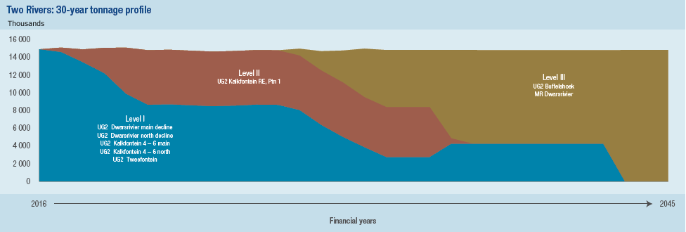
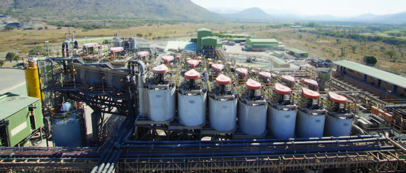
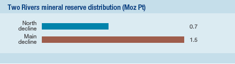
The larger portion of the mineral reserves (75%) is located in the Main Decline section. The 30-year profile of Two Rivers is shown. LoM I constitutes production from the Main and North Decline shafts. LoM II is an extension of the Main and North Decline infrastructure into the Kalkfontein and Tweefontein blocks. Various options are being considered for LoM III as depicted below. The profile is based on assumptions and may change in future. Limited trial mining was undertaken in 2012 on the Merensky Reef. This is on hold as full-scale mining of the Merensky Reef is not viable at present. Two Rivers has a concentrator plant on site where initial processing is done. It comprises a standard MF2 design as generally used in the industry. Concentrate is transported by road to Impala Platinum’s Mineral Processes in Rustenburg where further processing takes place in terms of an agreement with IRS.